EVO Lite 640T Enterprise · SE V2 controller · v1.0.2
| Aircraft | |
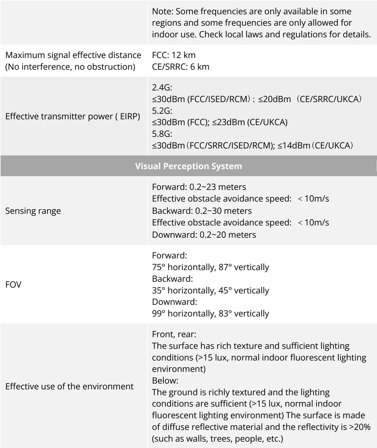
| Weightof EVO Lite Enterprise Series multi-rotor drone Maximum takeoff weightof EVO Lite Enterprise Series multi-rotor drone | 866g866g 210×123×95mm (folded, propellers included) |
| Dimensions Max. Rotation Speed Wheelbase | 433×516×95mm (unfolded, propellers included) 8000 rpm 368mmSlow:3m/s |
| Maximum ascent speed | Smooth:3 m/s Standard: 5m/s Ludicrous: 6m/s Slow:3m/s |
| Maximum descent speed | Smooth:2 m/s Standard: 3 m/s Ludicrous: 4 m/s Slow:3m/s |
| Maximum horizontal flight speed (no wind near sea level) | Smooth:5 m/s Standard: 10 m/s Ludicrous: 18 m/s |
| Maximum Service Ceiling Above Sea Level | 3000 meters Chinese Mainland or EU: no more than 120 meters US: no more than 400 feet |
| Maximum flight altitude | Note: In the flight application, it can be set from 0 to 800 meters. To set beyond height required by law, you need toobtain authorization from authority. |
| Maximum flight time (no wind) | 40minutes |
View the original table / diagram
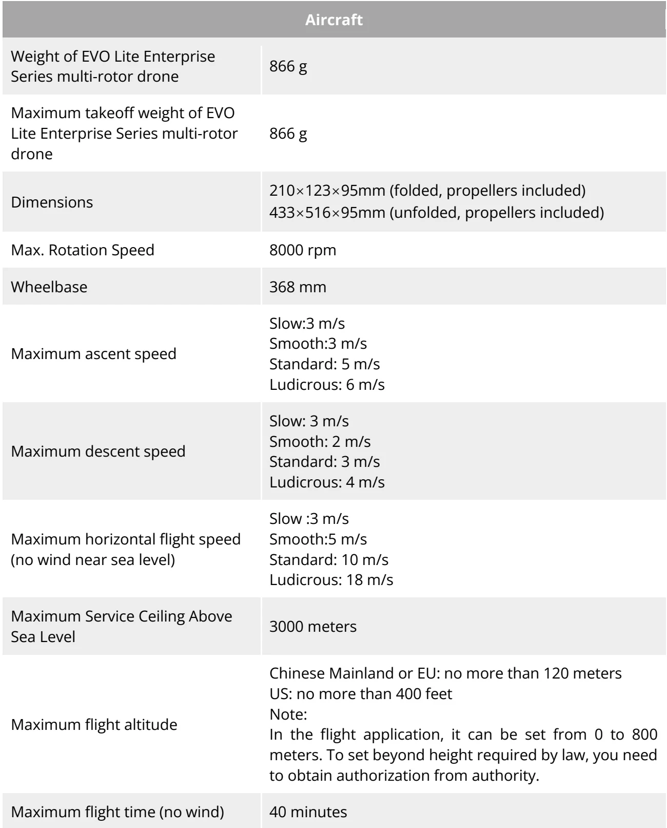
| Note: Tested in lab with nearly no wind when aircraft flies at speed of 10 m/s and only for reference. | |
| Maximum flight mileage | 24 km |
| Maximum hover time (no wind) | 37 minutesNote: Tested in lab with nearly no wind when aircraft hovers and only for reference. |
| Maximum wind speed resistance | 10.7 m/s |
| Maximum tilt angle | Slow: 15°Smooth: 30°Standard: 30°Ludicrous: 33° |
| Maximum rotation angular speed | Smooth: 60°/sStandard: 120°/sLudicrous: 200°/s |
| Working temperature | -10°C~40°C |
| Battery hot replacement | Not support |
| Internal storage | Onboard storage: 4GB (support microSD card of up to 256GB) |
| GNSS | GPS/BDS/GLONASS |
| Hover accuracy | Vertically:\pm 0.1 meters (when visual positioning is working normally)\pm 0.5 meters (when GNSS is working normally)Horizontally:\pm 0.3 meters (when visual positioning is working normally)\pm 0.5 meters (when High-Precision Positioning System is working normally) |
| Image Transmission | |
| Operating Frequency | 2.4G:2.400 - 2.476 GHz*, 2.400 - 2.4835 GHz5.2G:5.15 - 5.25 GHz**, 5.17-5.25GHz***5.8G:5.725 - 5.829 GHz*, 5.725 - 5.850GHz*Only applicable to SRRC regions**Only applicable to FCC, CE and UKCA regions*** Only applicable to Germany |
View the original table / diagram
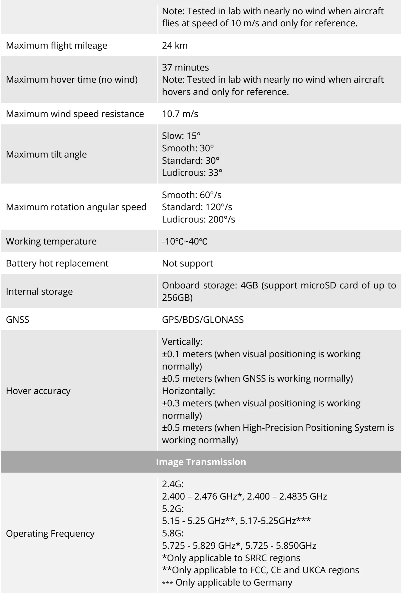
| Note: Some frequencies are only available in some regions and some frequencies are only allowed for indoor use. Check local laws and regulations for details. | |
| Maximum signal effective distance (No interference, no obstruction) | FCC: 12 kmCE/SRRC: 6 km |
| Effective transmitter power ( EIRP) | 2.4G:≤30dBm (FCC/ISED/RCM) ; ≤20dBm (CE/SRRC/UKCA)5.2G:≤30dBm (FCC); ≤23dBm (CE/UKCA)5.8G:≤30dBm (FCC/SRRC/ISED/RCM); ≤14dBm (CE/UKCA) |
| Visual Perception System | |
| Sensing range | Forward: 0.2~23 metersEffective obstacle avoidance speed: < 10m/sBackward: 0.2~30 metersEffective obstacle avoidance speed: < 10m/sDownward: 0.2~20 meters |
| FOV | Forward:75° horizontally, 87° verticallyBackward:35° horizontally, 45° verticallyDownward:99° horizontally, 83° vertically |
| Effective use of the environment | Front, rear:The surface has rich texture and sufficient lighting conditions (>15 lux, normal indoor fluorescent lighting environment)Below:The ground is richly textured and the lighting conditions are sufficient (>15 lux, normal indoor fluorescent lighting environment) The surface is made of diffuse reflective material and the reflectivity is >20% (such as walls, trees, people, etc.) |
View the original table / diagram