
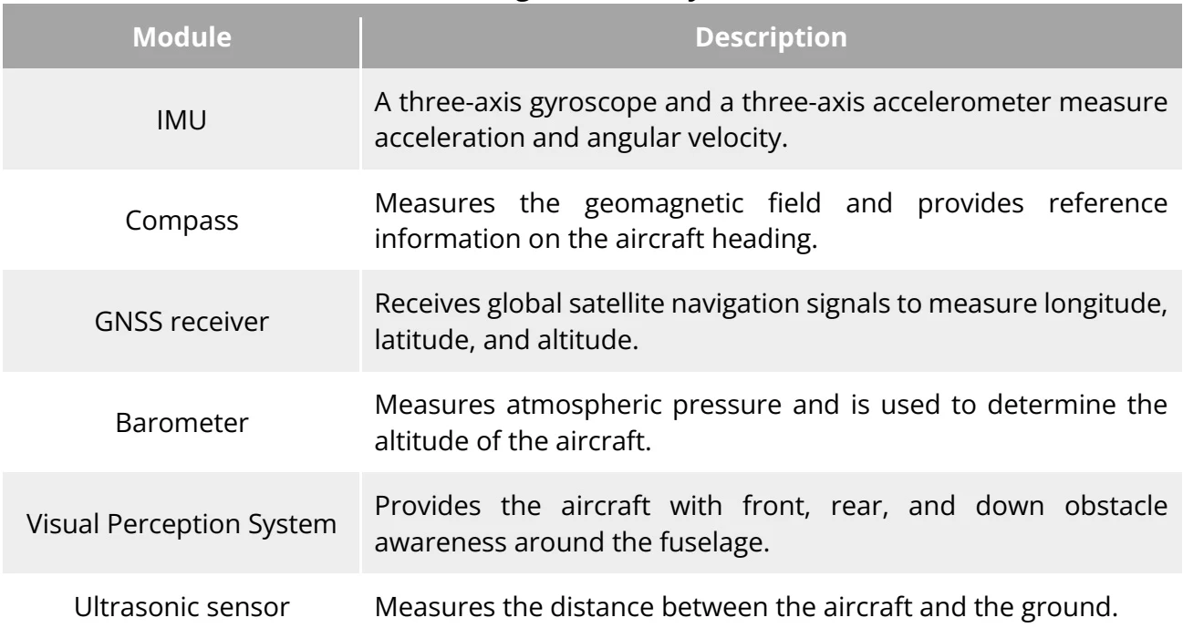
EVO Lite Enterprise Series multi-rotor drone achieves stable and convenient flight control through its built-in intelligent flight control system. The system supports a number of advanced functions, including auto-return, failsafe, and visual positioning system. PDF p. 57
| Module | Description |
| IMU | A three-axis gyroscope and a three-axis accelerometer measure acceleration and angular velocity. |
| Compass | Measures the geomagnetic field and provides reference information on the aircraft heading. |
| GNSS receiver | Receives global satellite navigation signals to measure longitude, latitude, and altitude. |
| Barometer | Measures atmospheric pressure and is used to determine the altitude of the aircraft. |
| Visual Perception System | Provides the aircraft with front, rear, and down obstacle awareness around the fuselage. |
| Ultrasonic sensor | Measures the distance between the aircraft and the ground. |
View the original table / diagram
3.8.1 Flight status
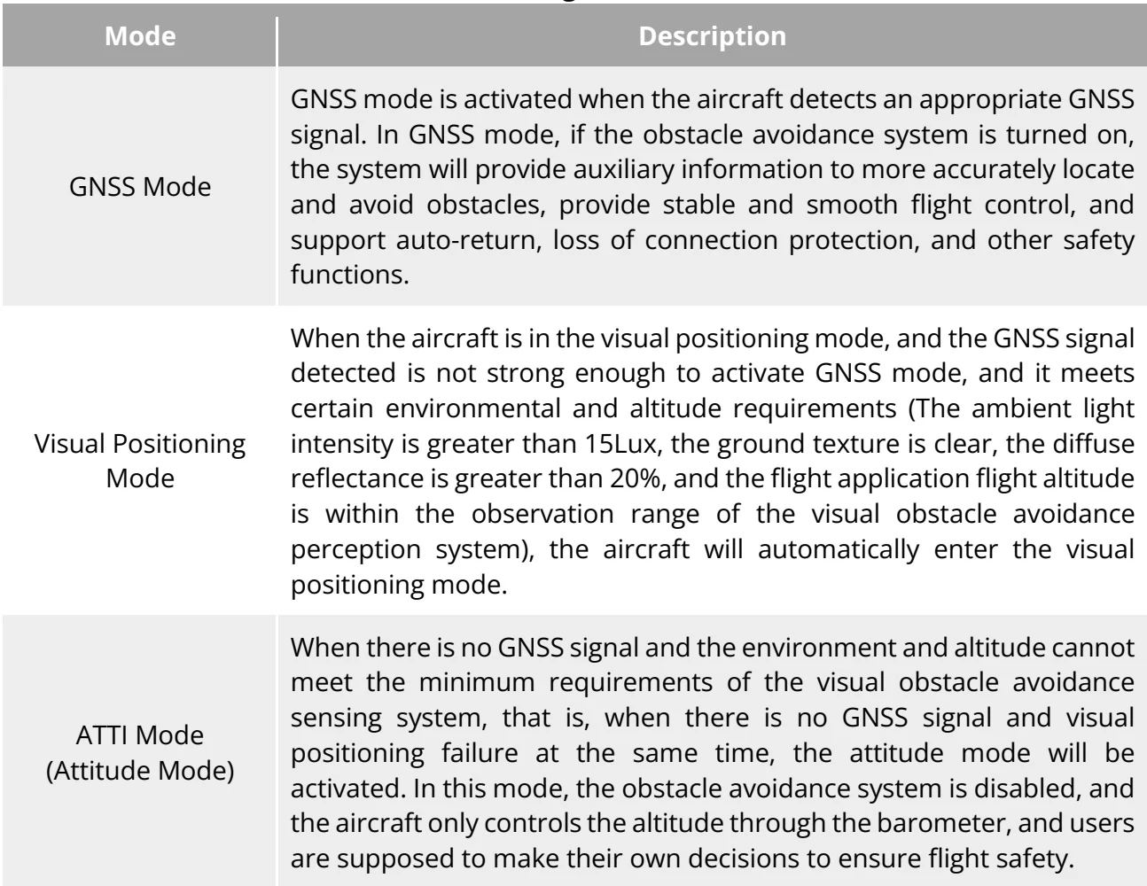
PDF p. 58| Mode | Description |
| GNSS Mode | GNSS mode is activated when the aircraft detects an appropriate GNSS signal. In GNSS mode, if the obstacle avoidance system is turned on, the system will provide auxiliary information to more accurately locate and avoid obstacles, provide stable and smooth flight control, and support auto-return, loss of connection protection, and other safety functions. |
| Visual Positioning Mode | When the aircraft is in the visual positioning mode, and the GNSS signal detected is not strong enough to activate GNSS mode, and it meets certain environmental and altitude requirements (The ambient light intensity is greater than 15Lux, the ground texture is clear, the diffuse reflectance is greater than 20%, and the flight application flight altitude is within the observation range of the visual obstacle avoidance perception system), the aircraft will automatically enter the visual positioning mode. |
| ATTI Mode (Attitude Mode) | When there is no GNSS signal and the environment and altitude cannot meet the minimum requirements of the visual obstacle avoidance sensing system, that is, when there is no GNSS signal and visual positioning failure at the same time, the attitude mode will be activated. In this mode, the obstacle avoidance system is disabled, and the aircraft only controls the altitude through the barometer, and users are supposed to make their own decisions to ensure flight safety. |
View the original table / diagram
3.8.2 Flight modes
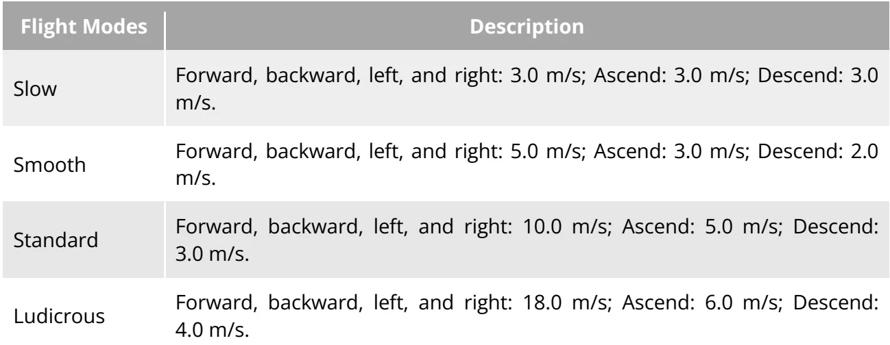
PDF p. 59| Flight Modes | Description |
| Slow | Forward, backward, left, and right: 3.0 m/s; Ascend: 3.0 m/s; Descend: 3.0 m/s. |
| Smooth | Forward, backward, left, and right: 5.0 m/s; Ascend: 3.0 m/s; Descend: 2.0 m/s. |
| Standard | Forward, backward, left, and right: 10.0 m/s; Ascend: 5.0 m/s; Descend: 3.0m/s. |
| Ludicrous | Forward, backward, left, and right: 18.0 m/s; Ascend: 6.0 m/s; Descend: 4.0m/s. |
View the original table / diagram
3.8.3 Intelligent flight function
PDF p. 59Accurate Landing
PDF p. 59The accurate landing function uses the downward binocular Visual Perception System of the aircraft to record the information at its take-off point. When the aircraft is returning to the home point or landing, vision algorithms are used to calculate the distance between the aircraft and PDF p. 59
the take-off point in real time so as to make sure that the aircraft successfully lands at the takeoff point. PDF p. 60
Landing Protection
PDF p. 60The landing protection function uses the downward Visual Perception System of the aircraft to create a depth image, and then calculates the flatness and angle of the depth image to detect whether the surface is flat enough for a safe landing. PDF p. 60
Intelligent Obstacle Avoidance
PDF p. 60The intelligent obstacle avoidance function uses the combined observation results of the visual sensing system and the forward millimeter-wave radar sensing system of the aircraft to calculate the optimal flight path, achieving obstacle avoidance in multiple directions. PDF p. 60